

When Native American Oral Histories are More Accurate than Archeological Evidence
Bearing witness to the Ice Age Missoula Floods of the Pacific Northwest even when it was at odds of the accepted science of the day.

On this Indigenous Peoples Day, I thought I’d share a story that is near and dear to me as a traveling physician amongst the reservations of the Pacific Northwest.
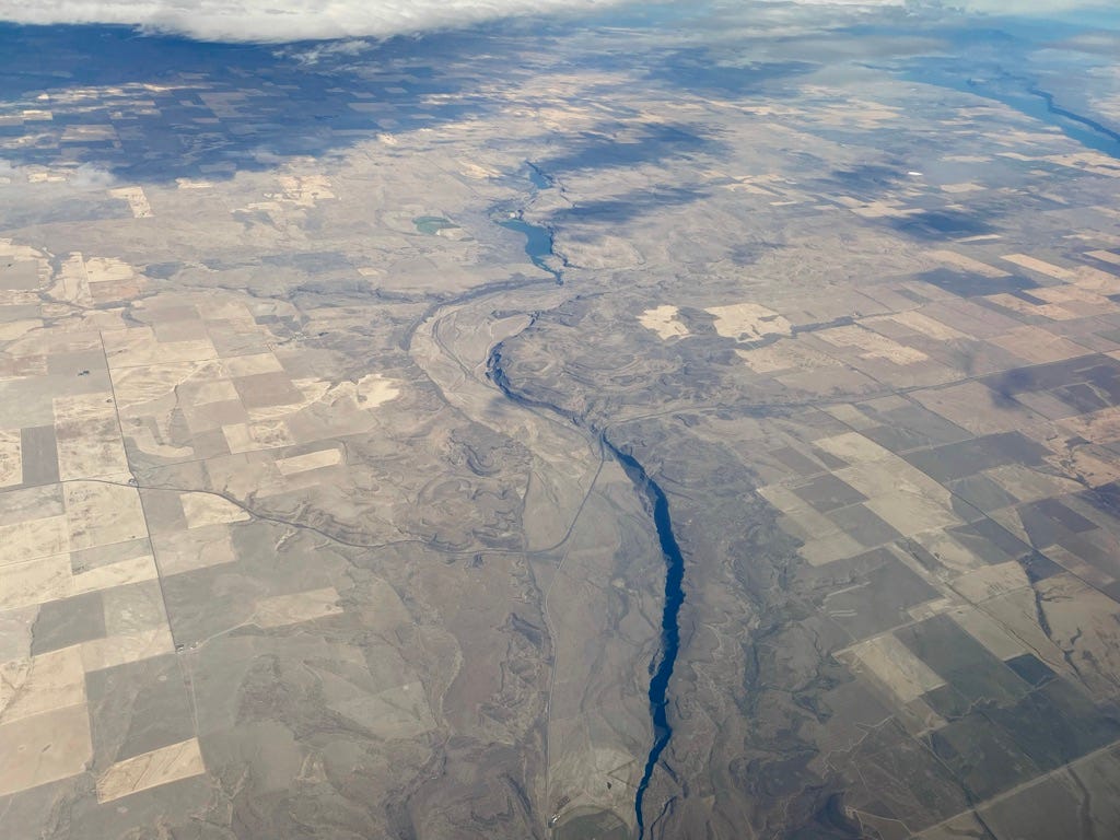
I took this photo of Moses Coulee in Central Washington on my flight from Seattle to Spokane when I was headed out for my most recent duty period for the Indian Health Service. Moses Coulee, named for Chief Moses of the Sinkiuse-Columbia tribe, is the second largest coulee after Grand Coulee which is just a short drive to the east. In fact, you can see Grand Coulee and the Banks Lake reservoir in it in the upper right of my photo.
The Sinkiuse-Columbia are one of the twelve tribes of the Confederated Tribes of the Colville Reservation in North Central Washington.
US-2 is the highway that crosses Moses Coulee at an angle in the middle of the photo. On my way home this past weekend, I drove through that spot to see what Moses Coulee looked like from ground level.

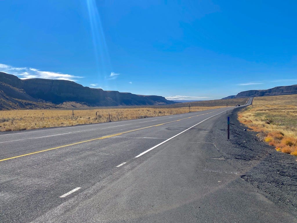
Coulee comes from a French Canadian word meaning "to flow"- couler. A coulee is a deep canyon whose original erosive force has long since disappeared. The Grand Canyon is not a coulee because the Colorado River is still there, cutting its way down to make the canyon deeper.
18,000 years ago in the Pleistoncene Ice Age (sometimes called the Last Glacial Maximum or the Wisconsin Glaciation), vast ice sheets had advanced from the Arctic deep into North America. A large finger of this continental ice sheet pushed into Idaho and blocked off the Clark Fork of the Columbia River. A 2000' foot high ice dam created a vast lake in Montana that was bigger than Lake Ontario and Lake Erie combined- Lake Missoula.
A second but smaller ice dam formed where the present day Grand Coulee Dam is located, creating a smaller but still large, lake that stretched the 90 miles eastward to where Spokane is now- this was Lake Columbia.
As the planet emerged from the last glacial maximum, the vast ice sheets began to melt and start to retreat. The ice dam that created Lake Missoula gave way- imagine a lake bigger than Lake Ontario and Lake Erie, emptying in less than 48 hours! A vast wall of water hundreds of feet high moving at over 60 mph scoured nearly all the topsoil for hundreds of miles, overwhelmed the second ice dam that formed Lake Columbia, and then carved out the Grand Coulee.
As the waters from Lake Missoula reached the Yakima Valley, they slowed and deposited thick fertile sediment in the valley which is why today's Yakima Valley is so fertile.
The ice dam in Idaho would reform, Lake Missoula would reform and the process repeated over and over again over 2500 years in what geologists call the "Missoula Floods". Each time, the coulees of central Washington were carved out further. Eventually the Missoula Floods reached today’s Oregon/Washington border and carved out the Columbia River Gorge east of Portland.
The Missoula Floods inundated the Wilamatte River Valley south of Portland, depositing thick layers of fertile sediment that today make the Willamette River Valley one of the big agricultural regions of the United States.
The floodwaters were so massive in their volume that there's an underwater canyon cut into the side of the continental shelf west of the mouth of the Columbia River at the bottom of the Pacific Ocean.
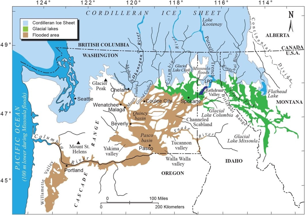
With the end of the Ice Age, Lake Missoula never reformed but Moses Coulee, like Grand Coulee, is one of many geographic features in the Pacific Northwest that are a legacy of those great floods. There are several coulees in this part of Washington State, Grand Coulee is the widest and longest followed by Moses Coulee.
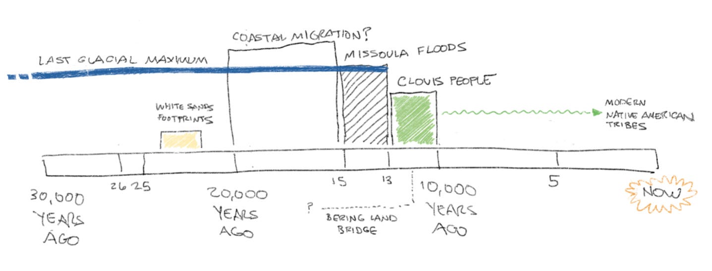
Many of the tribes of the Pacific Northwest have in their oral traditions accounts of massive floods, but for decades, these stories were treated as more myth than fact despite the assertions of the Native American tribes of the area. The reason for this was that for decades, it was accepted as fact that the ancient Clovis people are the ancestors of nearly all the Native American tribes and the Clovis people existed 10,000 to 13,000 years ago, after the Missoula Floods.
We know for certain that the peopling of the Western Hemisphere came from ancient tribes that crossed over from Siberia across the Bering Land Bridge towards the end of the Last Glacial Maximum- because so much of the planet’s water was locked up in vast continental ice sheets, the sea levels were a good 300 to 450 feet lower than they are today and a large land mass would have connected Asia to Alaska called “Beringia”. It was always assumed that the southward migration out of Beringia was blocked by the continental ice sheets until they had receded enough which led to the rise of the Clovis people.
More recently theories emerged to challenge the idea of “Clovis First”.
Given that the tribes of the Pacific Northwest coast have always had a sea-going tradition in their whale hunts, it’s not unreasonable their ancestors may have bypassed the continental ice sheets inland via coastal migration routes out of Alaska southward. Coastal migration would have easily taken place prior to the Missoula Floods- however many coastal settlements from 15,000-20,000 years ago and any archaeological evidence would have long been swallowed up by rising sea levels as the planet emerged out of the last glacial maximum.
More recently, scientists were able to reliably date sets of human footprints at White Sands National Park in New Mexico to 22,000 to 24,000 years ago, putting human habitation much further south and much further inland long before the Missoula Floods.
For the Native American tribes of the Pacific Northwest, this is not surprising. Given that their oral traditions essentially took the place of a written record in the absence of a written alphabet, these oral histories were an important record of their histories and origins. To them, they are more than legends and myths.
The Cheyenne tribes have accounts in their oral histories of multiple vast floods sweeping the area to the west of their lands in what is now northern Wyoming and southern Montana. The Nez Perce tribe have oral histories that recount the formation of the Columbia River Gorge as it was carved out by large floods. The Yakama have descriptions of “big water coming” and having to ascend the ridges above the Yakima Valley to escape the floods. The Warm Springs tribes of Oregon describe having to paddle to the slopes of Mount Jefferson (called “Seekseekqua” to them) to escape the flood waters. The Shoshone tribes of Idaho even describe being in the area over 20,000 years, predating the Clovis people.
Such stories are common in the oral histories of the tribes of the inland Pacific Northwest that would have been affected by the Missoula Floods.
The reliable dating of the human footprints in a sense, validates to science what the tribes of the inland Pacific Northwest have always known- their peoples were witness to the Missoula Floods long before the Clovis people arose.
In a sense, that is something even more fascinating than the Missoula Floods- that there is an unbroken line of human history and witness to those events manifest in the oral histories of the Native American tribes of the region.